
Enlarge Image
|
|
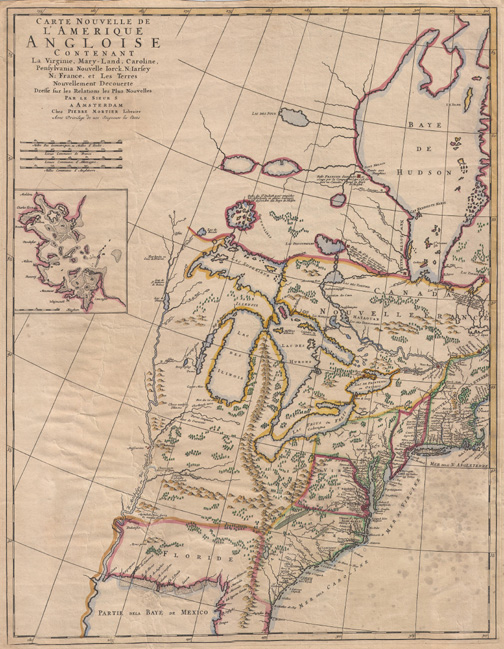
| Carte Nouvelle de L’Amerique Angloise Contenant La Virginie, Mary-Land, Caroline, |
| Pierre Mortier Pierre
|
|
Acquisition Number: 1960.129.005
Original work:
Original size: 24.25 by 21.5 inches
One map entitled ”Carte Nouvelle de L’Amerique Angloise Contenant La Virginie, Mary-Land, Caroline, Penssylvania, Nouvelle Iork, N: Iarssey, N: France, et Les Terres Nouvellement Decouerte Dresse sur les Relations les Plus Nouvelles [New Map of English America Containing Virginia, Maryland, Carolina, Pennsylvania, New York, New Jersey, New France, and the New Lands Discovered Based Upon the Relations of More News].” The map is printed in black ink on a slightly yellowed linen paper. Red, yellow, blue, and green lines have been used to highlight boundaries and topographic features. It was published by Pierre Mortier in Amsterdam in 1700 just one year before the founding of Detroit in 1701. The map covers the area of the United States and Canada east of the Mississippi River from Hudson Bay southward to the Gulf of Mexico. The names of principal lakes, rivers, forts, towns, and Indian tribal regions are shown in French along with lines of latitude and longitude. A small amount of text is in Spanish and English. An inset map on the left side shows Boston and the adjacent Boston Harbor area.
Reproduction Size: 20 x 25.75
|
|
